Street graph pruning
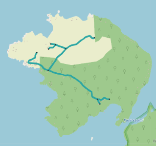
A street graph created from OpenStreetMap data has sections which cannot be reached with some or all traverse modes. For example, true geographic islands are usually disconnected from the main graph. The street network of such islands should be kept so that routing within the island or continuing from a ferry stop on it works as expected. Even a tiny street network connected to a ferry stop improves routing to an island a lot, because coordinate based itinerary searches find something to project onto.
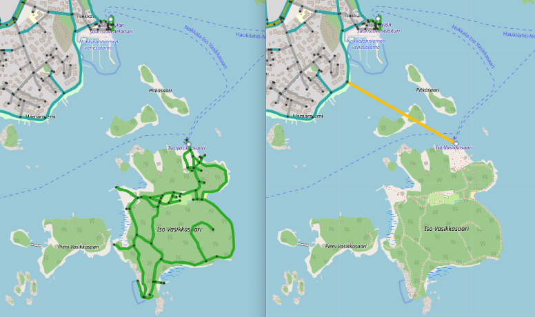
Removing a small subgraph from an island causes poor routing. A ferry stop on the island links
directly to mainland.
Disconnected parts can also represent a strictly forbidden area, such as connections within an industrial unit, roads of a military base or another region which cannot and should not be accessed when using door to door routing of a public transit journey planner. Existence of such graph sections is harmful, because start and end points of an itinerary search request may accidentally get projected to such a private pathway. As a result, a user does not receive any itineraries and gets no explanation for the routing problem.
In most cases, connectivity problems are caused by incorrect modeling of OSM data. The number of such errors is usually very large, and the problem cannot be solved by simply fixing OSM data as soon as errors are detected - the OSM street network in Finland contains over 10 000 detected walk connectivity issues! An algorithmic solution is needed to address a problem of such magnitude.
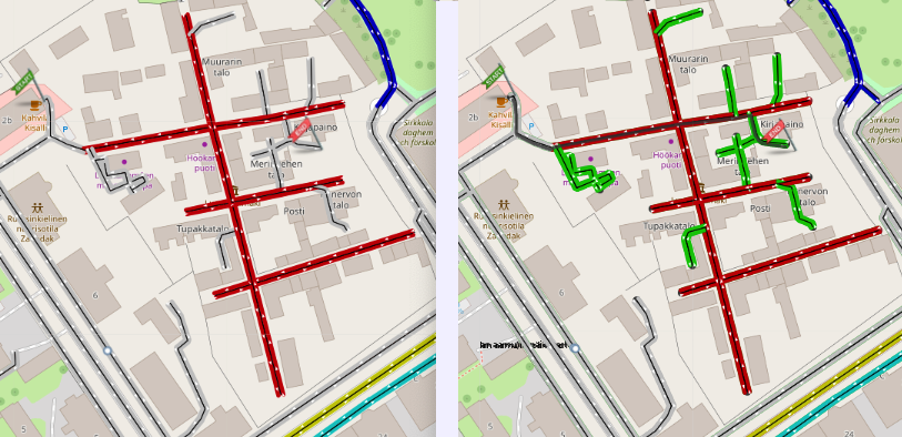
A typical error: bus platforms are not connected to the street network at all
A simple and efficient solution is to detect harmful disconnected parts and remove them from the street graph. Routing then uses the properly connected part of the graph and finds itineraries. As a side effect, the start point of an itinerary search which departs from the removed graph projects at the border of it, which usually is good enough. Transfers may include strange teleportation and unexpected walking, as public transit stops may link to somewhat remote streets, but at least transfers will work.
A disconnected railway platform breaks routing. Traveler is guided to take a round trip around the
country although there is one hour direct train connection.
Access restriction islands
One common reason for OSM connectivity problems is access tagging. It is perfectly OK to tag a front
yard of a private residence using access=private or access=destination tags, so that strangers
are not guided to travel through the private area. Routing will still use the private streets if a
trip starts or ends there - only pass through traversal gets prohibited. However, sometimes OSM
contributors try to block the traffic by tagging only entrance segments of streets leading to a
restricted area. Unfortunately this totally prevents access to the interior part of the network,
because OTP interprets it as pass through traffic. Pruning handles such problems by converting
streets behind an access restriction to have the same access properties.
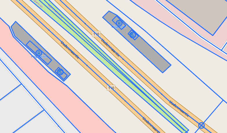
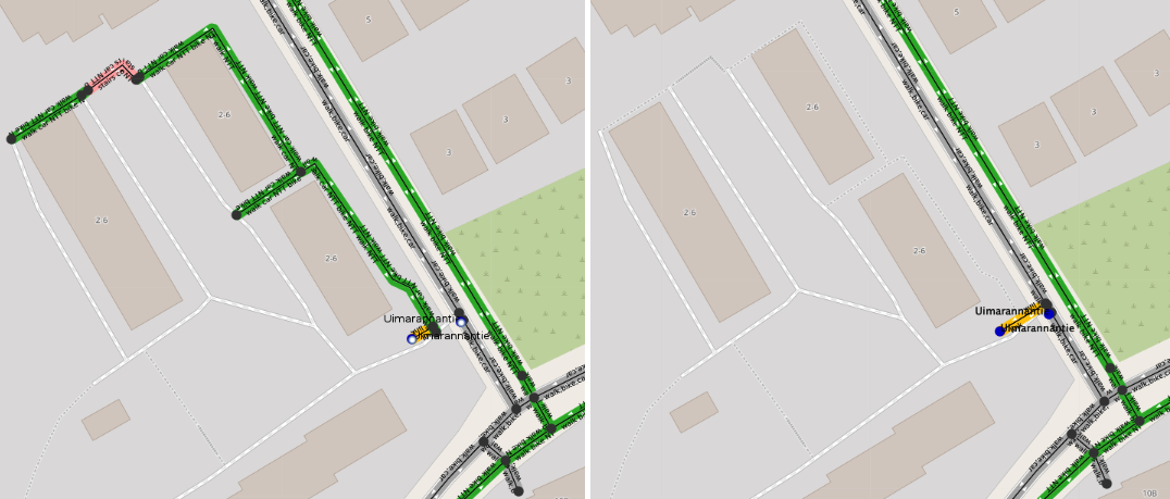
Some regular (gray colored) streets are blocked behind access restricted (red colored) connections.
Walk routing to them fails because it would be considered as pass through traffic. The image on the
right shows that pruning added walk nothrough restriction to those streets, and routing works
again.
Pruning algorithm
Pruning analyses the three traverse modes - walk, bike and car - separately. For example, a resting area by a motorway may include some walking paths, but the only way to get there is to use a car. Therefore, it represents a disconnected 'island' when considering the walk mode. Pruning does not erase disconnected graph geometry as long as it can be reached using any of the traverse modes. Instead, pruning removes traversal permission for each disconnected mode from the island.
Pruning uses four parameters and some heuristics to decide if a disconnected sub graph is a real island to be retained, or a harmful data error:
islandWithStopsMaxSizedefines the threshold for graph islands, which include public transit stops. All stop islands which have fewer graph edges than this get pruned. Default value is 2.islandWithoutStopsMaxSizedefines the threshold for graph islands, which do not have public transit stops. All stopless islands which have less edges than this get pruned. Defaults to 10.adaptivePruningFactordefines the maximal value for a distance based multiplier for the two thresholds defined above (default value 20).adaptivePruningDistancedefines the search radius as meters when estimating distance between graphs (default value 250).
Pruning thresholds are increased adaptively so that if the distance between an examined sub graph
and the other graph is zero, the threshold is multiplied by a full adaptivePruningFactor value. The
idea is that if a sub graph is closely entangled with another graph, it is likely to be a harmful
modeling error, not a remote place like a true geographic island. If the distance is more than
adaptivePruningDistance, the actual nominal threshold values will be used. So, adaptiveness prunes
much larger disconnected graphs in places where they have potential to cause routing errors.
Adaptive pruning can be disabled by setting adaptivePruningFactor to 1. Constant pruning thresholds will then be applied.
Pruning also examines the transport modes of graph islands with stops. If land transportation modes are not found (only ferry or no modes at all), the graph is retained. Unknown mode is accepted for island status, because ferry lines often operate only during warm seasons.
Some examples
A disconnected small graph should be preserved, if it is located on a real island.
A street section has tags which prevent traversal on it, and OTP has removed it from the graph.
Some isolated streets remain left, and a public transit stop gets linked to them. Routing cannot use
the stop unless traveler is leaving from or going to the small isolated sub graph. Isolated streets
cannot be reached by walking either. After pruning, the stop is projected to the main graph.
Transfers at the stop work fine. Itineraries can guide traveler quite close to the removed streets.
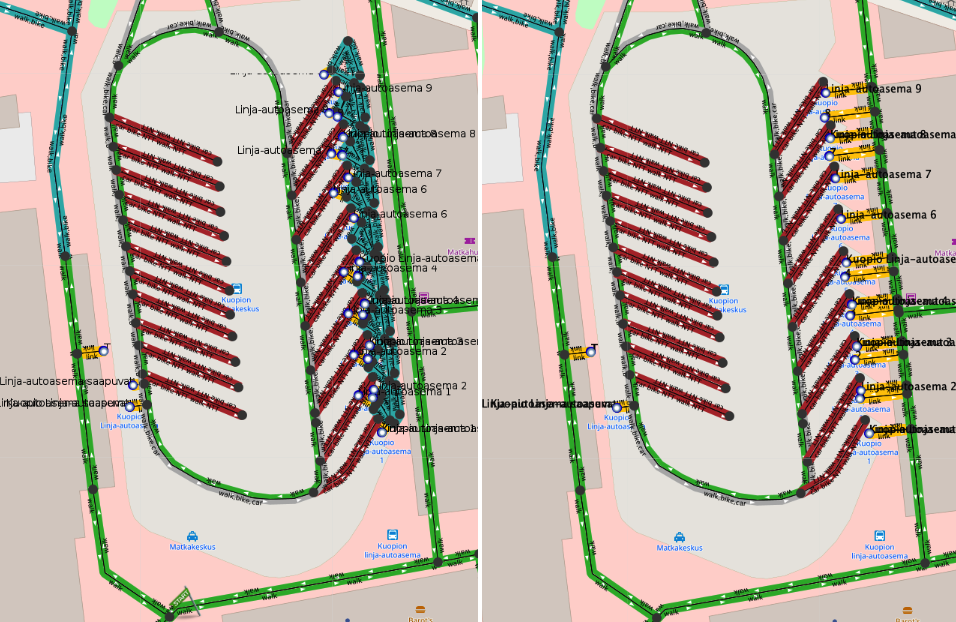
The platform structure of a bus station is disconnected from the other graph. Most bus traffic of a
medium size city becomes unusable. Despite of the complexity of the sub graph (54 edges and 21
stops), it must be removed in pruning, so that stops get linked to reachable and well connected
streets.
Issue reports
Pruning creates a GraphIsland issue every time it prunes a sub graph. Issues may show up as
duplicates, because pruning is run for each traverse mode.
A PrunedStopIsland issue is added for every pruned graph island which has stops linked to it. Such
islands are particularly harmful, because they are places where public transit transfers take place
and hence are frequently used. Pruned stop island issues should be studied frequently and underlying
OSM errors fixed, especially if the island has many stops and edges (i.e it is most likely a public
transit station, see station island example above).